Winter Burrow Map Guide – In-Game Map Update, Community Maps & Route Index
A practical Winter Burrow map hub: what changed after the map update, which community maps are useful, what public interactive references include, and which route guide matches each blocker.
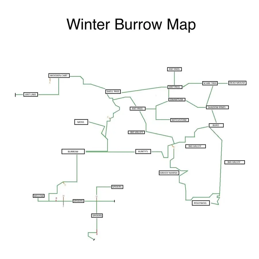
Static community reference map (credit: winterburrow.site community). Use it with the updated in-game map and the route index below. Open full‑size for details.
01
Guide Step
Quick Answer: best map setup right now
If you only need the fastest answer, use three layers together: the updated in-game map for direction, a community map for labels, and this route index for blockers. The in-game map helps you avoid walking in circles, but it does not tell you whether a route is blocked by Pickaxe, Flint, Heavy Key, Shovel, Willow, or Mole Artifact progress. The community map helps with named regions, but you still need route notes when the screen refuses to open. For fast travel locations and mole tunnel locations map searches, start with the tunnel/shovel pages instead of staring at a world image; those shortcuts depend on Willow notebook, shovel state, and whether the tunnel has actually been inspected.
Map first: open the in-game map when you need broad direction or storm return safety.
Community second: compare labels on winterburrow.site when you need BUFO, MOSS, AUNTIE, POLLYWOG, or region names.
Route third: open the dedicated guide when the problem is a blocker such as Pickaxe, Flint, Granite, Heavy Key, tunnel, or Mole Artifact.
02
Guide Step
What changed with the map update
Older Winter Burrow guides often say there is no in-game map. That advice is outdated: the post-launch map update added one. Open it for broad orientation, for checking whether you are moving toward the right named region, and for planning a return before darkness or bad weather. The in-game map does not replace route instructions. It cannot tell you that a visible passage needs the Granite Pickaxe, that a tunnel prompt depends on Willow's Notebook and the Flint Shovel, or that the Heavy Key only matters after Moss activates A missing key. Use a labeled community image when you need regional names, then open the route guide for the exact NPC, item or blocker. That three-step process prevents a correct map pin from sending you to a place your current quest state cannot enter.
Use the in-game map first when you are lost, returning in a storm, or checking your broad direction.
Use community maps when you need named labels such as BUFO, BIG VALLEY, SHADOW PINES, AUNTIE, or POLLYWOG.
Use route guides when the problem is a blocker: Pickaxe, Flint, Granite, Heavy Key, tunnel access, thick vines, or quest state.
Do not trust any one static map as complete. The best maps are useful anchors, not perfect coordinate systems.
03
Guide Step
Best current map options
There are three useful map layers, and none should be treated as perfect. The in-game map is the safest choice for current orientation because it reflects the version you are actually playing. The static maps collected at winterburrow.site are useful for named regions and a quick full-world overview. The map/wiki at winterburrowgame.com is useful as a secondary reference, but its public page does not yet replace a verified, pin-by-pin route tool with prerequisites. Player map threads on Reddit can clarify a tunnel or late-game branch, but screenshots there may come from a different quest stage or game version. Compare the broad region first, then verify the final screen with an in-game landmark and the route-specific screenshots on this site.
In-game map: best for broad orientation after the map update and for checking whether you are moving toward the right region.
Community static maps: best for Bufo, Moss, Aunty, Pollywog, resource zones, and rough region shapes.
Developing map/wiki pages: use as a cross-check only when a pin lacks a screenshot or prerequisite.
Route index below: use when you know the target but a tool, key, NPC state, or tunnel blocks the path.
04
Guide Step
Route index for common blockers
Choose the route by the thing that is actually blocking you. A world map answers direction; it does not explain why a rock ignores the Pickaxe, why a vine will not cut, why a tunnel has no prompt, or why an item is absent before its quest begins. The paths below are real links. Open the one that matches the wording on your HUD or the object on screen before spending supplies on another blind run.
Even with the map update, Winter Burrow still works better if you read routes as landmarks instead of coordinates. The screen language is consistent: waterlines reset direction, grass bands hide exits, hollow logs mark deliberate transitions, stone and granite mark different tiers of gates, and campfires tell you where a return path should feel safe.
Write routes as short sentences. “BUFO -> shoreline south -> stone gate -> grass band -> broken logs -> campfire” is easier to remember than a vague screenshot. For the Moss chain, use task-specific anchors such as the Heavy Key skull, north-west vine gates, abandoned caravan, Fine Woollen Hood clearing, and final Flint boulders. That is how you avoid staring at a fan map, walking two screens, and still not knowing whether you are on the correct path.
Water edge: follow it when you need to reset direction or return to a known NPC area.
Tall grass: scan the far edge for darker gaps before assuming the path is closed.
Hollow logs and tunnels: usually mean a real region transition, not decoration.
Stone vs. Granite: check the tool requirement first. If the node does not break, the map is not wrong; your progression is early.
Campfires: use them as route memory. Light the one near a fork before chasing a quest item.
Use the labeled community map as an anchor, then verify direction with the updated in-game map.
06
Guide Step
Two safe practice loops
Before doing item-specific routes, practice two short loops by daylight. The goal is not to clear the whole world; it is to learn how the map, landmarks, weather, and return path line up. If you cannot describe the next turn in words, shorten the run.
Bufo-side practice loop: start near Bufo, hold the shoreline as your compass, cross only one blocker, then return before dusk. This prepares you for Pollywog and early stone/Flint confusion.
Moss-side practice loop: start from Moss, reach the Heavy Key skull, take the left exit, clear the north-west vine gates, then stop at the abandoned caravan fire. This rehearses the Fine Woollen Hood route using visible checkpoints.
Granite gate check: visit one Granite blocker only to verify tool state. If it fails, go back to Bufo progression rather than brute-forcing the map.
A wider community map view is useful for choosing the next target, but route articles still matter for prerequisites.
07
Guide Step
Five questions the map cannot answer by itself
A map can show where a region sits, but Winter Burrow often blocks progress through quest and tool state. Before assuming the map is wrong, answer five questions: Which NPC gave the current task? What exact line appears on the HUD? Which visible object blocks the exit? What is the equipped tool name? What landmark proves this is the correct screen? If those answers do not agree, a second map image will not fix the route. Return to the NPC or workbench, correct the missing state, then use the same landmark chain again.
Is there a better map? Use the in-game map for orientation and community maps for labels; no public fan image is a perfect coordinate chart.
Is there a complete interactive map? Not one that reliably includes every quest and tool prerequisite. Route screenshots remain necessary.
Where is Pollywog? Start at Bufo and follow the shoreline, two rock gates, broken logs, and campfire.
Where is Pinesap? Finish the Heavy Key and Fine Woollen Hood, then use the Flint Pickaxe left of the hood clearing.
Why can I see a place but not enter? Check the tool tier, active quest, key, or tunnel prompt before changing maps.
Use a secondary map to cross-check labels, then verify blockers and route state before leaving.
08
Guide Step
Next routes to check after the map
If the map tells you the direction but you still cannot progress, stop treating it as a navigation problem. At that point you are usually missing a tool, a quest state, or a key item. Work through the blocker in this order before you spend another night walking the same loop.
Tool blocker first: Pickaxe, Flint, Granite, and Shovel searches usually mean you are at a material gate, not that the map is hiding a shortcut.
NPC route second: Pollywog and Pinesap are named-location problems. Start from Bufo or Moss and follow a known landmark chain instead of sweeping the whole forest.
Quest-state third: Heavy Key, tunnel, and Mole Artifact problems usually need the right conversation or inventory state before the path makes sense.
Safety last: once the prerequisite is correct, run the route by daylight, carry one emergency tea, and light a campfire near the fork before going deeper.
09
Guide Step
What to do when the map feels stuck
First separate a broken map feeling from a blocked route. If the map opens but your path does not match the image, you are probably comparing a static community map to a patched in-game route or reading a route from the wrong starting NPC. If the map shows the right region but the screen refuses you, it is usually a tool gate, quest state, or hidden prompt. If the map itself does not update after the Winter Solstice feature, reload the save, sleep once, and check whether the quest or region has actually been discovered.
Use this quick test: can you name your current start point, the target, and the blocker? “Moss -> Heavy Key -> vines/skull” is a route problem. “Willow -> tunnel -> no dig prompt” is a quest-state or bug problem. “Bufo -> Granite -> rock will not break” is a pickaxe problem. “Map opens but I do not know which screen is mine” is an orientation problem. Once you name it that way, the correct article becomes obvious.
Map looks different from a fan image: trust the updated in-game map, then use landmarks rather than exact proportions.
Map shows the region but no progress: check the route prerequisite, not another map image.
Tunnel prompt missing: use the Willow tunnel page and verify Notebook, Flint Shovel, and home-side dig state.
Tool gate blocks you: use the Pickaxe, Granite, or progression unlock guide before walking farther.
10
Guide Step
Frequently Asked Questions
Short answers before you choose another map or repeat a long route.
Is there an in-game map now? A: Yes, the map situation changed after launch. Use the updated in-game map for orientation, then use fan maps and route notes for labels and blockers.
What is the best Winter Burrow map? A: The best current setup is in-game map + winterburrow.site static maps + WinterBurrow.org route pages. No single public map is complete enough to replace route guidance.
Is there a finished interactive map? A: Not a fully verified public map that includes every item, NPC, tool gate, and quest prerequisite.
Why does the community map not match what I see? A: Static maps can be partial, stretched, or missing newer details. Trust tool gates, NPC state, and visible landmarks over exact proportions.
What should I do when a map route is blocked? A: Identify the object, read the HUD, verify the equipped tool, then open the matching route card below.
Supply Tip 1
Use the updated in-game map for orientation, then route pages for blockers.
Supply Tip 2
If the marked region is visible but unreachable, check the tool, key, tunnel, or quest prerequisite before walking again.
Supply Tip 3
Run new routes by day first; add tea/campfire if the planner shows Danger.
Yes, the map situation changed after launch. Use the updated in-game map for direction, then use community maps and route guides for labels, resources, and blockers.
What is the best current map?
The best setup is layered: in-game map for orientation, static community maps for labels, and WinterBurrow.org route pages for Pickaxe, Flint, Pollywog, Pinesap, Granite, Heavy Key, tunnels, and Mole Artifact.
Is there a real interactive map?
No public map currently verifies every pin, tool gate, and quest prerequisite. Use the in-game map for region orientation, then open the route page that matches the object or objective blocking you.
Why can I see the route but still be blocked?
Most failures are progression checks, not map errors. Check the required tool, NPC quest state, key, or tunnel unlock before spending more warmth on the same path.